New England – Here’s the latest on the Nor’easter that is approaching…
Key Information:
- Widespread Heavy Snowfall
- High Travel Impacts
- Strong Winds, especially in the western White Mountains, and Grafton County
–> Which would increase the chances of Power Outages in that area - Minor Coastal Flooding possible
SNOWFALL FORECAST:
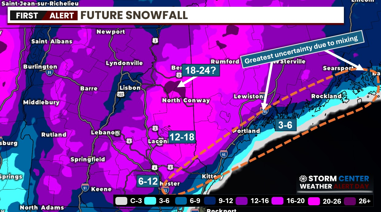
I am expecting that the storm will dump heavy snowfall across the state Wednesday Afternoon/Evening into Early Friday Morning.
The North Country of New Hampshire, White Mountains, and Lake’s region will likely get 12-18 inches out of this storm, with areas such as Conway, North Conway, could receive over 18 inches in some localized communities. Some southern areas, not so much. This will all depend on the rain snow boundary that will set up during the storm. I have outlined an area for Southern Maine, as well as the Southern parts of New Hampshire, such as the coastal areas of Rockingham County, Southern Strafford County, and far Eastern Hillsborough County
The farther west you go, the more snow you will get in the higher elevations such as the Monadnock Region. This area could get 12-18 inches, again in localized communities and higher elevations.
WINDS:
Winds will likely be 25-25 MPH with gusts at times upwards of 60 MPH especially in the western White Mountains, and parts of Grafton County. This will likely lead to possible power outages in that area, and across the state as the winds increase, and the heavy wet snowfall will weigh down branches and trees causing them to fall.
TIMING:
Timing for this storm will be starting Wednesday Afternoon/Evening, and continuing throughout the day on Thursday, and possibly into Early morning hours on Friday. Some snow showers will likely be continuing on and off throughout the day.
ALERTS:
Winter Storm Warnings have been issued for all 10 counties of New Hampshire until Thursday April 4th, at 8 PM You can view warning information here: https://forecast.weather.gov/showsigwx.php?warnzone=NHZ015&warncounty=NHC011&firewxzone=NHZ025&local_place1=Milford%20NH&product1=Winter+Storm+Warning&lat=42.8347&lon=-71.6471
WARNNG DETAILS:
URGENT - WINTER WEATHER MESSAGE
National Weather Service Gray ME
332 PM EDT Tue Apr 2 2024

NHZ007-008-011-015-030745-
/O.UPG.KGYX.WS.A.0008.240403T1200Z-240405T1000Z/
/O.NEW.KGYX.WS.W.0007.240403T1800Z-240405T0000Z/
Sullivan-Merrimack-Cheshire-Western And Central Hillsborough-
Including the cities of Goshen, Weare, Claremont, Keene, Sharon,
Unity, Jaffrey, Marlow, Lempster, Surry, Grantham, Goffstown,
Gilsum, Mont Vernon, Hooksett, Dunbarton, Loudon, Peterborough,
Newport, Charlestown, Milford, Cornish, Amherst, Concord, Hollis,
Sullivan, Canterbury, Croydon, and Boscawen
332 PM EDT Tue Apr 2 2024

...WINTER STORM WARNING IN EFFECT FROM 2 PM WEDNESDAY TO 8 PM EDT
THURSDAY...

* WHAT...Heavy snow and sleet expected. Total snow accumulations
  between 6 and 12 inches, and sleet accumulations around one inch.
  Higher amounts up to 18 inches are expected in the Monadnocks.
  Winds gusting as high as 45 mph.

* WHERE...Western and Central Hillsborough, Merrimack, Sullivan, and
  Cheshire Counties.

* WHEN...From 2 PM Wednesday to 8 PM EDT Thursday.

* IMPACTS...A snowstorm will bring plowable snow to the region with
  a period of moderate travel impacts expected. The combination of
  heavy wet snow and strong winds will lead to snapped branches and
  downed trees, resulting in power outages. Significant snowfall and
  periods of heavy snowfall rates will combine with low visibility
  to create very dangerous driving conditions. The hazardous
  conditions could impact the Wednesday evening and Thursday morning
  commutes.

* ADDITIONAL DETAILS...This is a expected to be a long-duration,
  multi-faceted event. While precipitation starts Wednesday,
  intensity will increase Wednesday night into Thursday when some of
  the heaviest rates may fall accompanied by strong, gusty winds. Be
  prepared for a prolonged duration of impact.

PRECAUTIONARY/PREPAREDNESS ACTIONS...

Do not touch downed lines and report any power outages to your
electric company. Travel is highly discouraged due to slick roadways
and the possibility of downed trees and power lines.

&&

$$